
Few hobbies could utilize a navigational tool more than hiking.
With the perils of dangerous trails and the potential to get lost amid the vast wilderness, choosing the right GPS unit can mean the difference between danger and security.
Of course, there’re several navigational tools to consider, and one of them is phone GPS. But as convenient as phone GPS is, it’s not reliable since it’s restricted by network range. This isn’t to mention phone GPS lacks water and shock resistance, crucial elements for an outdoor tool.
For everyday use in the front country and backcountry, it’s hard to beat a traditional compass and map, but a hiking GPS will do most of the heavy lifting for you.
A map will tell you where to go, and any skilled outdoorsman can make their way to any destination with just a compass. But the best GPS devices for hiking will help you avoid problems on the way and make your journey more comfortable and enjoyable.
But not all GPS devices fit the bill for the perfect gadget for the outdoors. The best GPS for hiking differs wildly from what urban GPS offers. For example, having a touchscreen GPS is convenient and nice but might not be the best option in the woods.
While the best GPS devices for hiking may not necessarily have the best cutting-edge technologies or the longest list of features, they’re practical, reliable, and durable even in the harshest conditions.
We’ve rounded up a list of the best GPS devices for hiking based on what you may need in your next expedition.
Table of Contents
- 1 In A Hurry? Here's Our Choice!
- 2 Table of Contents
- 3 Quick Comparison Table!
- 4 The Best GPS Devices for Hiking For The Money
- 5 #1 Garmin GPSMAP 64st - EDITOR'S CHOICE
- 6 #2 Garmin Foretrex 401 Waterproof Hiking GPS - Best Instant Satellite Connection
- 7 #3 DeLorme InReach Explorer - For Extreme Hike and Backcountry Terrains
- 8 #4 Garmin eTrex 35t GPS Navigator - Touchscreen Option
- 9 #5 Bad Elf 2200 GPS Pro - Best for Data Logging
- 10 Best GPS Devices for Hiking Buying Guide
In A Hurry? Here's Our Choice!
Our top pick on our list of the best GPS devices for hiking is the Garmin GPSMAP 64st.
We choose this option because we feel it comes with everything hikers would need for better navigation.
It utilizes both GPS and GLONASS navigation system to provide an accurate description of your location, regardless of the existing conditions, including the canyon-like conditions.
The device is also quite rugged because it’s reliable and will handle the wild like a champ. It doesn’t break easily and will survive the falls and ding. Most importantly, it rated IPX7, so it’ll survive the heavy rains and even accidental submersion into the water.
Of course, it lacks some bells and whistles like the Hotflix technology for faster connection to the satellite, but we feel it’s not a sufficient reason to deny the device our top pick.
Table of Contents
Quick Comparison Table!


The Best GPS Devices for Hiking For The Money
#1 Garmin GPSMAP 64st - EDITOR'S CHOICE
- Quality
- Price
- Our Rating
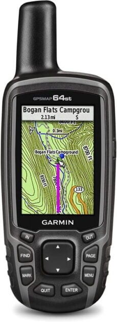
If antique appeal means something to you, you should consider the Garmin 64st. It brings the memories of the old Nokia phones.
Yet, it’s a pragmatic option, offering one of the most accurate navigation systems.
The 64st, closely identical to its ancestral 62 model, is loaded with a host of smart and new features, and you’ll find fewer bugs and more accuracy.
Keep reading to know more about this device:
Features and Benefits
Design
Garmin has gone for a chunky architecture with the aesthetics of an old-school walkie-talkie.
With a length of 6 inches, 2.4 inches in width, and more than half a pound in weight, this option has a rather clunky build, but you’ll appreciate it once you start using it.
The unit fits ergonomically in the hands, with the rubberized exterior ensuring it doesn’t slip. And despite its size, you can tuck it into your breast pocket, but the antennae will stick out.
While the GPS won’t take any prizes for a revolutionary design, it has a functional focus any outdoor enthusiasts will appreciate.
First, it has a sturdy shell, enough to survive the accidental drops and bruises. The IPX7 rating is another impressive feature, allowing you to use the product even in rain, snow, and submersion into depths of one meter for up to 30 minutes. The GPS should be able to take an accidental soak in a shallow stream without leaving you high and dry.
Also, Garmin 64st retains the traditional push-button design, and the buttons are easy to use, so users shouldn’t face any problems whatsoever when using the device.
Navigation System
Garmin 64st is a great option for those looking for a dependable GPS device.
It combines GPS and GLONASS effectively to give an accurate location even in the wooded locations with a heavy tree canopy.
In particular, the Russian GLONASS works wonderfully in canyon-like environments and northern latitude, thus you can never get lost with the device.
The quad-helix antenna also helps with better satellite reception, even in closed spaces, and will make your adventure a memorable one.
Expanded Memory
Navigating you to the right location alone is not enough.
The 64st has an 8GB internal memory and expandable memory SD card slot to store up to 200 routes and mark up to 5000 waypoints.
Here, you can store some of the points you think are essential for your hiking trips, such as eateries, medical care junctions, point or photography, and other important points.
Maps
Garmin 64st comes with an in-built worldwide base map.
The TOPO US version has maps comparable to the USGC maps, adequately covering everything you need on your locality, including rivers, roads, seasonal streams, and coastline.
It also gives you the elevation profile, so it’s easy to estimate how challenging your hike will be.
Wireless Sharing and Notifications
An intrinsic feature of the 65st is connectivity. It lets you connect the GPS to other GPS devices or smartphones and share data.
It’s possible to share the waypoint or geocaches with other hiking teams and even receive texts and emails on your device instead of your smartphone.
Battery Life
The battery life is essential for any handheld device, and this option doesn’t fail in this department.
Garmin 64st uses two options. You can choose the rechargeable batteries for a long-lasting experience or two standard AA batteries.
Pros
- Multi-GNSS
- In-build word base map
- Internal and expandable storage
- Wireless connectivity
- Barometric altimeter and electronic compass
Cons
- Take a few seconds to lock to satellites
#2 Garmin Foretrex 401 Waterproof Hiking GPS - Best Instant Satellite Connection
- Quality
- Price
- Our Rating
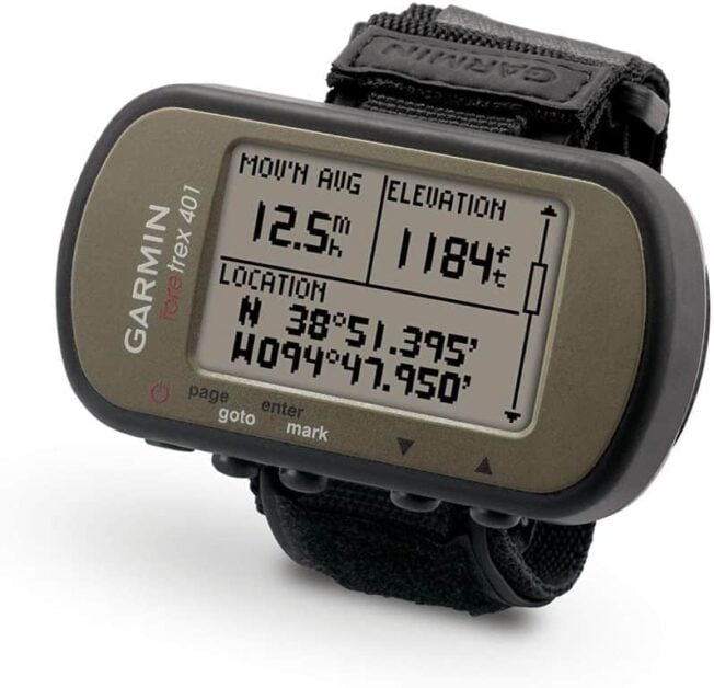
Our runners up option, the Garmin Foretrex 410, was initially designed with the military in mind but can be quite a life-saver for the regular hikers.
One quirky thing with this GPS is the presence of a wrist band, and it’s lightweight enough to be worn like a hiking watch.
Other than that, the Foretrex’s features are elaborate. Many outdoor enthusiasts will love the fantastic navigational features it has to offer.
But is it the right GPS device for you?
Features and Benefits
Design
Most of the handheld GPS is pocketable, but few consider convenience.
But not the Garmin Foretrex!
It’s a wrist-mounted option, and while it’s a little bulky for something you’d wear all day on your hands, it’s lighter than the traditional handheld trackers.
It’s also incredibly lightweight and a great option for anyone looking for a decent model at a bargain price that you won’t have to hold when using.
The compact size doesn’t make it less appealing for outdoor enthusiasts because it’s sturdy and will take on the rugged conditions like a champ. It survives drops and accidental dings.
It also has an IPX7 rating, pretty standard on most Garmin models, so it will survive accidental splashes, rain, snow, and accidental falls in streams that won’t leave you hanging dry.
Navigation System
Garmin Foretrex, unlike our top pick, uses GPS alone to settle your location and navigate.
Does it make it less inferior?
Absolutely not, considering it also utilizes HotFlix, a proprietary Garmin’s technology that lets the device lock in the satellite right away.
It gives an instant reception even under heavy trees and brush cover. You can also get accurate navigation results even in the pouring rain.
TrackBack
One of the sensational features of the ForeTrex 410 is the ability to store up to 10 routes, and this is useful when you need to retake the same path.
There’s also a TracBack feature that can retrace your route and steps. It’s an essential feature that will get you back to your starting point if you stray too far into the wilderness.
Dual Position Readouts
The ForeTrex 410, with military chops, allows you to configure the device for MGRS.
It’s possible to get the 10-digit grid in dual position readout for instant access.
You can also customize the display with four quadrants to show the relevant information only.
Connectivity
ForeTrex 410 may look simple, but it supports a wireless connection through Bluetooth.
It’s possible to connect wirelessly to tracking accessories like cadence monitors, heart rate monitors.
You can also connect the device to your computer or smartphone through USB cables to transfer all your important data.
Display
ForeTrex 410 lacks a colored display. Instead, it packs a 1.7 inch LCD.
The absence of coloration isn’t a deal-breaker because the display is fairly large and rich in contrast, making it easier to read even during the bright sunny day.
For the night, the backlight helps you see the route metrics.
Battery
The battery is a strong feature on the ForeTrex 410, with the 2 AAA offering up to 15 hours of use.
Pros
- Modest
- Compact and lightweight
- Wrist-mounted
- Instant satellite connectivity
- Decent battery life
Cons
- You need to calibrate your compass often
#3 DeLorme InReach Explorer - For Extreme Hike and Backcountry Terrains
- Quality
- Price
- Our Rating
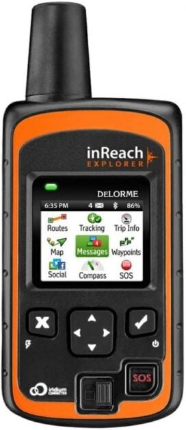
The InReach Explorer is more than a handheld GPS navigation device.
Instead, it also serves as a beacon, global satellite communicator, and a full-function GPS navigator.
It might as well be the perfect substitute for your cellphone when you need to communicate with your friends and family at home or even send an SS distress call in an emergency.
With so much to offer in terms of communication, I find the Explorer the perfect device for outdoor enthusiasts planning to explore past the limits of the regular adventure points.
Features and Benefits
Design
As with our top pick, Garmin 64st, the Inreach Explorer’s design rekindles the nostalgic Nokia phone design.
It’s a beefy unit, with the sticking antennae making it look like every bit of a satellite communicator.
However, it’s still ergonomic for the bulky size and possible to hold it in your hands or even put it in your hand warmer or breast pocket.
Though not the most rugged option, it still appeals to outdoor enthusiasts, thanks to sturdy construction and a waterproof rating of IPX6.
The screen is also large enough to allow you to see all the route details. It’s also aesthetically pleasing, with the colored screen a welcome from the bland black and white displays.
Communicator
Satellite communication is probably the main takeaway with this GPS device.
It’s possible to send text messages to people when you don’t have cell service.
You can either add contacts to the device itself or use the Earthmate app to access your contacts.
The device also integrates several common present messages for easier communication.
SOS
You should probably invest in this GPS device to benefit from the SOS capability, which lets you communicate with emergency responders in case you’re in a distress situation.
With the SOS button activated, you can send or receive messages from the appropriate emergency responders.
Navigation System
InReach is more than a rescue device or communicator; but will also help with the navigation.
It features a GPS, a digital compass, and a barometric altimeter.
Combined, both of these features will provide an accurate description of your location.
And the good thing is the GPS performance is quite reliable and will give a detailed description of your location even when you’re under a layer of trees or even in the canyons.
Once connected to the satellite, you can view data, either on the device itself or through an installed app on your Android or iPhone.
Battery Life
InReach Explorer has a fantastic battery life of 100 hours. But you need to keep in mind it’s more oriented towards communication.
Using the device as a navigational tool will certainly drain the battery faster.
Overall, the InReach Explorer is a pretty awesome device, and though its navigational capabilities might be quite limited, it’s the perfect option for emergencies.
It allows your family to keep track of you in real-time, and the SOS feature is quite handy when you’re in a distressing condition.
Pros
- Navigation and satellite communication capabilities
- Durable
- Instant SOS alert
- Compass, barometer, and altimeter
Cons
- Activation/suspend procedure is tedious
#4 Garmin eTrex 35t GPS Navigator - Touchscreen Option
- Quality
- Price
- Our Rating
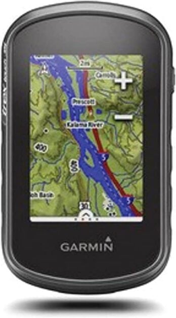
If you fancy your GPS device with a touchscreen display, you might consider the Garmin eTrex 35t.
It’s a step-up to the old eTrex 30 GPS, and though it has the same features as its predecessor, it has been pumped up with newfangled additions like a barometric altimeter, so it’s easy for hikers to acquire the correct altitude, elevation, and weather data.
Features and Benefits
Design
The design quality of the Garmin eTrex 35t is not any different from what we’ve seen on our previously reviewed items.
It’s quite compact, lightweight, and will easily slip into your pockets without you hardly noticing.
The compact dimensions and measly weight makes it possible to keep the GPS handy at all times, either on your breast pocket, in your hand, backpack, or your pants pockets.
The design also appeals to the hikers as the outer hard plastic shell is pretty robust and can handle a few knocks. The casing is equally tight and works well to protect the inner components from dust, dirt, and humidity.
However, because of its rather larger touchscreen, you must handle it with care.
It also has an awesome waterproofing rating of IPX7, so you don’t have to worry about getting caught up in the rain or getting wet by mistake while hiking.
Navigation
Garmin eTrex 35t is among Garmin’s landmark devices to go all out with the navigational capabilities.
As with our top pick, Garmin 64t, this option utilizes both GPS and GLONASS system for accurate and detailed location descriptions.
In addition to both GNSS platforms, it also utilizes Garmin’s Hotfix system, which we had earlier seen on our second pick, the Foretrex 410.
You shouldn’t have any issues pinpointing your exact location, even under deep tree cover or even inside a building with all systems activated. Even better, the device will give you a result without any delay.
Geocaching
Using the Garmin eTrex 35t is a delight as this option is preloaded with thousands of geocaches that store all the key information for your treasure hunt.
It also serves as the resource center for your terrain, location, and descriptions.
This is not to mention the device has an 8GB memory enough to hold up to 200 routes and accommodate 4000 custom waypoints to help you create comprehensive journeys for future journeys.
Connectivity and Versatile
The Garmin eTrex 35t is the perfect GPS multi-tool as you can connect it to other tools such as your phone, laptop, or even Garmin-compatible camera.
It’s also a versatile and accommodative GPS device as it features pre-set profiles, which you can select to suit your activities. Here, you can choose from hiking, cycling, running, and other profiles.
Other Features
As a true value purchase, the eTrex 35t is, it comes with a host of other features to help with easier navigation.
For instance, the 3-axis tilt-compensated electronic compass will show your direction even when standing, so it’s always easy to get your bearing regardless of where you’re.
On the other hand, with its 3D positional feature, the altimeter will help you pinpoint your exact location.
Pros
- Incredibly light
- Intuitive controls
- Reliable navigation
- Easy connectivity
Cons
- The battery life of 8 hours is short.
#5 Bad Elf 2200 GPS Pro - Best for Data Logging
- Quality
- Price
- Our Rating
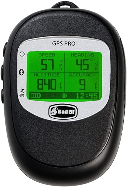
The Bad Elf is a unique GPS device that functions like a data logger and a receiver, designed to connect with your iPhone, iPad, and iPod products.
Now as simple as the device looks, it’s packed with a host of applications that will let you share your location with your family, fellow hikers, or anyone else with a similar device.
Features and Benefits
Design
The Bad Elf is a tiny device, a compact and lightweight option that will fit into your hands with relative ease.
This GPS device’s front face is segmented into four quadrants, with each quadrant giving you different data.
It also comes with a lanyard strap and is supplied with a neck lanyard, so carrying the device should be a breeze.
It’s not the most rugged option on our list, but it’s rated IPX4, so it should be immune to water splashes and light rain. I would advise you to use it in thunderstorms or even submerging it in water.
Navigation
Bad Elf combines navigation and data logging.
The device offers up to 100 hours of position storage, and it creates a datalog by taking your GPS location every one second.
The datalog feature is essential as it helps in recreating a continuous path of all your activities. The good thing with this feature is that it’s easy and cheaper to document your journey than the expensive devices that offer survey-grade positions.
When it comes to navigation, the GPS reception is accurate and will hold its connection strong even under canopy cover or even inside a room.
Connectivity
Another real benefit of this device is the BlueTooth connectivity.
Unfortunately, Bad Elf only supports devices with up to 5 iOS, and the wireless connectivity isn’t available for Android devices.
For the iOS, the connection is seamless, and there’s nothing that you can’t transfer, including your location and even your datalog.
Map
For those that have used the Garmin 64st or 35t, you might be a little disappointed to learn that this option lacks a map-based system.
However, it’s not a big issue because the Bad Elf is a fantastic device that combines a GPS receiver’s best capabilities and the high resolution of smartphones and tablets.
Pros
- Data logging capability
- Ability to export data
- Accurate and speedy GPS reception
Cons
- Not detailed navigation system
Best GPS Devices for Hiking Buying Guide

Choosing the best GPS devices for hiking is a challenging feat, considering there’re numerous options, each with distinctive features to consider.
Fortunately, we’ve compiled a definitive guide outlining everything to consider in your next selection process.
Factors to Consider When Selecting the Best GPS Devices for Hiking
GPS Satellite Connection
Satellite connection is the primary purpose of a GPS.
Different brands can tap into different networks and no longer rely on the American GPS.
Garmin takes the lead with the ability to connect to GLONASS, a Russian satellite network. GLONASS works well in boosting the receiver’s performance in deep canyons and under heavy cover.
Other GNSS systems include the European Galileo network, which brings accuracy down to about two meters.
The ideal GPS should connect properly to the GPS to allow you to determine the location, and by extension, guide you to your destination.
Touchscreens Vs. Buttons
Touchscreen GPS is increasingly becoming popular because of the appeal and convenience.
As with smartphones, touchscreen GPS devices are also growing in popularity.
However, the touchscreens cannot be relied on in rough and rugged conditions.
Those hiking in the backcountry should opt for buttoned devices.
Battery Life
Battery life is a crucial characteristic of GPS products.
Different devices use different battery types-either replaceable or rechargeable. Neither is necessarily better, but you’ve to weigh the options.
If you’ll be relying on GPS or extended periods without access to charging ports, then battery life is essential.
On the other hand, if you’ll be using your GPS intermittently or for short periods, then the battery’s life falls down the pecking order.
It’s always advisable that you don’t take the manufacturer’s claim for battery life as the gospel truth, and you should always have a spare set of batteries just in case.
Mapping And Memory
All GPS units feature the base map, including major local features and some additional preloaded maps.
The newer models give users the option of uploading more maps later on-either through a USB or Bluetooth connection to a smartphone.
Altimeter, Barometer, And Compass (ABC)
The best or rather premium GPS devices have extra features, including:
- Altimeter: It gauges the elevation using air pressure
- Barometer: Aids in weather forecasting. It’s also handy for mountainous and backcountry uses as it provides an approximation of your current elevation.
- Compass: The built-in three-axis electronic compasses are wonderful in that they don’t need to be kept flat like a traditional compass. They give the GPS accuracy with small movements, and the navigational arrow and map will orientate with you.
Size and Weight
GPS units don’t vary much in weight and size, but if you need an easy to backpack option, choose a light and compact device.
Durability
Durability is paramount for a GPS device for hiking.
GPS devices are rarely used in cushioned environments, but rather in rugged and wild conditions.
Your choice of GPS devices should survive the wetness of the wild and the minor scrapes, bruises, and knocks.
If you’re a rugged climber, you should consider something that will be sturdier and more substantial.
Broken hiking GPS won’t be of any use to your quest, so find an option rugged enough to keep up with your active lifestyle.
Ease of Use
While GPS’s user interface is more of a personal choice, it’s vital in determining what you want in your product.
Some of the GPS comes with an incredibly simplistic and basic design, which is fine for the lower-priced items.
But you may want something a little bit fancy and dynamic.
For instance, you can choose an option offering a colored/illuminated screen to give you the best view of the terrain possible.
Additionally, some models utilize a touch screen instead of the soft keys, which is again a matter of personal preferences.
Frequently Asked Questions (FAQs)
Q: What does GPS Stand for?
A: GPS is an abbreviation for Global Positioning System
Q: How does GPS work?
A: GPS units work by using information relayed to satellites to determine location. They triangulate the device’s location against multiple satellites to figure your position on the face of the Earth.
Each GPS transmits a signal to multiple satellites, and depending on the time needed to reach each satellite; the units can determine how far away you’re from each of them.
Q: Can a GPS replace a compass and topographic maps
A: No, hiking GPS can never be an alternative to a map or compass. A GPS can malfunction or run out of battery. And in questionable situations, a map will never mislead you. That said, GP is perfectly capable of leading you to safety in nearly 99% of all scenarios.
Sharing is caring!
